Underground Utilities Survey
Underground Utilities Survey
Accurate surveying and utility detection services for locating, tracing and documenting underground utilities and buried services to support safe excavation, design, construction and infrastructure development.
Accurate Data for Underground Utilities
Reliable information for identifying buried services, their locations and routes
Underground Utilities Survey is a specialized surveying service used to identify, locate, trace and document underground utilities and buried services within a project area before or during construction and excavation activities.
The work focuses on locating existing underground infrastructure such as water lines, drainage networks, electrical cables, communication lines, gas pipelines and other buried services, and connecting the detected information to the project coordinate and elevation reference system whenever applicable.
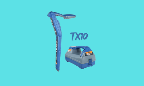
The appropriate detection and surveying method is selected according to the type of utility, expected depth, ground conditions, site environment and project requirements. Depending on the conditions, the work may include the use of TX-10, GPR, GPS / GNSS, Total Station and 3D Laser Scanner.
The collected field information is processed, reviewed and correlated with available drawings and existing records whenever possible. The results are then presented through utility maps, surveyed coordinates, levels and technical documentation to provide a clear representation of the detected underground services and their relationship with the surrounding site.
Scope of Underground Utilities Survey
Detection, tracing, surveying and documentation of buried services
Utility Location & Tracing
Locating and tracing underground utility routes and identifying accessible points and visible utility features across the survey area.
Water & Drainage Networks
Surveying water and drainage networks and documenting related features such as manholes, chambers, valves and accessible connection points.
Electrical & Communication Services
Detecting and surveying suitable electrical and communication services and documenting their identified routes and associated surface features.
Gas & Other Buried Services
Surveying gas pipelines and other buried services according to the applicable detection method, site conditions and project requirements.
Underground Utilities Survey Methodology
A structured process for utility detection, surveying and documentation
Site Assessment & Available Data Review
Detection Method & Equipment Selection
Underground Utility Detection & Tracing
Surveying & Coordinate Referencing
Elevation & Utility Feature Survey
Data Verification & Comparison
Utility Mapping & Final Documentation
Underground Utility Detection & Surveying Equipment
Selecting the appropriate technology according to utility type and site conditions
TX-10
Used as part of underground utility detection and tracing activities where its detection capabilities are suitable for the type of buried service and field conditions.
GPR
Ground Penetrating Radar technology used to investigate subsurface conditions and assist in detecting buried utilities and other underground features.
GPS / GNSS
Used for accurately positioning detected utility points and features and connecting the survey results to the project coordinate reference system.
Total Station
Used for precise surveying of utility features, surface references and detected locations where high positional accuracy is required.
Applications of Underground Utilities Survey
Supporting safe excavation, design, construction and infrastructure projects
▰
Construction Projects
Identifying existing underground services before foundations, structures and other construction activities are executed.
╱
Roads & Infrastructure
Mapping utilities within road corridors, infrastructure projects and areas planned for development or rehabilitation.
⌁
Excavation Planning
Providing utility information before excavation to help reduce potential conflicts with existing buried services.
▱
Utility Mapping
Creating and updating digital maps showing existing underground utilities and associated surface features.
⌘
Engineering Design
Providing surveyed utility information to support engineering design, coordination and assessment of potential conflicts.
⚙
Existing Infrastructure Documentation
Documenting existing utility networks and infrastructure for maintenance, expansion and future development works.
Underground Utilities Survey Deliverables
Clear surveying data and technical documentation of identified utilities
Utility Location Data
Surveyed locations and coordinates of identified underground utilities and associated surface features.
Utility Routes
Drawings and data showing the identified routes and alignments of underground services within the survey area.
Utility Maps & Drawings
Digital maps showing detected utilities, surveyed points, surface features and relevant project information.
Survey Report
Technical documentation describing the survey methodology, equipment, detected information and final results.
Reliable Utility Data Before Excavation
Underground utilities surveying provides valuable information about existing buried services before excavation and construction activities. Accurate utility location data helps engineers, contractors and project teams understand existing site conditions and identify potential conflicts with planned works.
Detection results depend on factors such as utility type, material, depth, ground conditions, surrounding infrastructure and site environment. Therefore, the appropriate detection and surveying technology is selected according to the actual site conditions, and detected field information is clearly distinguished from information obtained from existing drawings or records.
Do You Need an Underground Utilities Survey for Your Project?
Total Surveying Office can assess your project requirements and provide underground utility detection, surveying, mapping and documentation services using appropriate detection and surveying technologies.
Need this service?
Request a free, no-obligation quote and our team will get back to you shortly.
Request a Quote